
Introduction
While California is often the main focus of earthquake analysis, seismic hazards are also increasing in other regions across the U.S. Two (2) prominent areas of concern are the Pacific Northwest and the Central U.S., where growing seismic activity is prompting updates to government risk models. Government risk models and community planning efforts are being updated to consider the growing concern in these regions.[1]
Areas of Impact
Earthquakes are primarily caused by fractures or faults in the Earth’s crust; however, a variety of other forces impact this process. Stress from tectonic plate movement and surface loading can eventually create faults. While most faults are inactive because of constant stress or pressure, a change in stress levels can reactivate faults. The magnitude of an earthquake is also based upon fault location, movement of the fault, rock properties, and rock strength. These factors contribute to the different characteristics of earthquakes in various locations across the U.S.[2]
As tectonic processes continue to shift, these areas must be prepared for increased seismic activity in the coming years. According to the United States Geological Survey (USGS), 37 states in the U.S. have experienced a magnitude five (5) earthquake or larger over the last 200 years, with approximately three (3) quarters of the U.S. estimated to experience damaging earthquakes in the future.[1]
Pacific Northwest
Beneath northern California, Washington, and Oregon run the Cascadia Subduction Zone. Earthquakes along this 1,300-kilometer plate-boundary fault can significantly impact populations in the Pacific Northwest. The Cascadia Subduction Zone tectonic boundary lies between the North American continental plate and the Juan de Fuca and Gorda oceanic plates. This 700-mile fault runs from northern California to British Columbia, 70 to 100 miles off the Pacific coast shoreline.[1],[3]
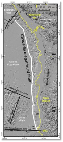
Figure 1 – Cascadia Subduction Zone[3]
There have been 43 earthquakes within the last 10,000 years at this fault. The last known earthquake in this area occurred in January 1700 and was estimated to be a magnitude 9.0 event. As tectonic strain has accumulated over the last 325 years, future earthquakes in this area have the potential to reach magnitude 6.5 or higher. Based on past earthquake timing, there is an 85% chance of a magnitude 6.5 or greater deep earthquake in the Puget Sound Region within the next 50 years, a 17% chance of a magnitude 6.5 or greater crustal fault earthquake there within the next 50 years, and a 10% to 15% chance of an approximately magnitude 9.0 Cascadia Subduction Zone earthquake within the next 50 years.[1]
An earthquake in the Cascadia Subduction Zone would significantly impact the land and the surrounding communities. A 2022 state and federal planning exercise for an earthquake in the Cascadia zone found that around 14,000 fatalities, 100,000 injuries, and collapse of 620,000 buildings might occur. The study also found that the zone is at a higher risk for major earthquakes due to its smoother and flatter nature. Damage to transportation infrastructure was estimated to impact up to 16,000 miles of highway, 6,000 miles of railways, 700 port facilities, and 100 airports.[1],[4],[5],[6]
An earthquake in this zone could also trigger subsequent shaking, tsunamis, coastal flooding, and sinkholes. A 2025 Proceedings of the National Academy of Sciences (PNAS) study, in collaboration with USGS, showcases how an earthquake of magnitude 8.0 or greater in this area could cause land subsidence of 1.6 to 6.6 feet, raise local sea levels, and increase the risk of coastal flooding. It was assessed that by 2100, earthquake subsidence could triple the flood risk to residents. Future tsunami inundation maps should consider the possibility of a future Cascadia Subduction Zone earthquake and subsequent earthquake-driven subsidence. The map below highlights a ShakeMap scenario situation for a Cascadia zone magnitude 9.0 earthquake using ground-motion intensities. This planning exercise found that if a Cascadia earthquake were to occur, coastal areas and sediment-filled basins would be hit the hardest.[1],[7],[8],[9]
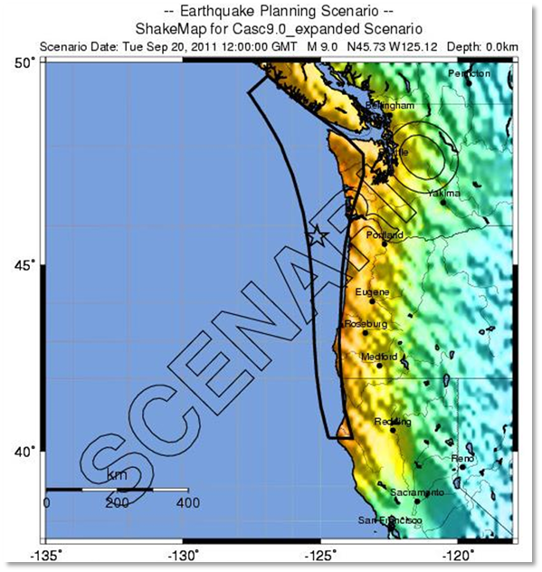
Figure 2 – Cascadia Subduction Zone Earthquake Planning Scenario[9]
Central U.S.
The Central U.S. is another area of concern that has not received as much attention in terms of increasing seismic activity. The New Madrid Seismic Zone, showcased below, is the most active seismic area east of the Rocky Mountains. The New Madrid Seismic Zone is centered in the central Mississippi Valley and extends through portions of southeastern Missouri, northeastern Arkansas, western Tennessee, western Kentucky, and southern Illinois. Major regional cities that could experience impacts from a significant New Madrid earthquake include Memphis, Tennessee; St. Louis, Missouri; and Little Rock, Arkansas. The New Madrid fault system produced the major earthquake sequence of 1811 and 1812, which included several large earthquakes and numerous aftershocks. During the 1811–1812 earthquake sequence, seismically generated waves, riverbed deformation, and local ground uplift caused water on the Mississippi River to move upstream in places, creating reports that the river appeared to flow backward.[1]
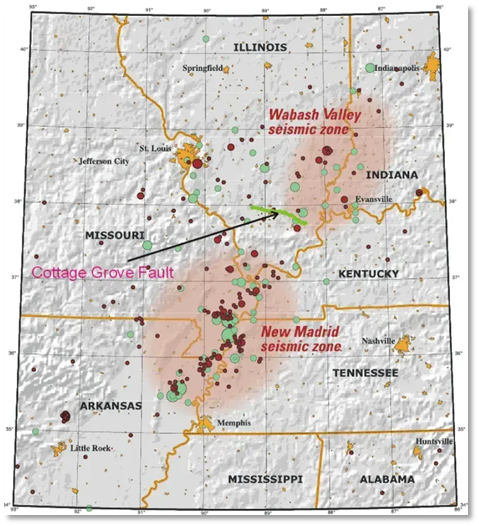
Figure 3 – New Madrid Seismic Zone[1]
Several geological factors may contribute to future significant earthquakes in the New Madrid Seismic Zone. For example, the colder and older crust located in the central and eastern U.S. allows earthquakes to travel greater distances. Overall, this allows earthquakes to impact larger areas. Another important geological consideration is the soft soil of the Mississippi Valley, which can increase shaking intensity throughout the region. As earthquake waves increase, increased shaking may significantly impact surrounding communities.[1]
The areas that would be impacted the most from a New Madrid Seismic Zone earthquake include Tennessee, Kentucky, Missouri, Illinois, Indiana, and Mississippi. An earthquake in any of these areas would cause widespread infrastructure damage to bridges, hospitals, supply chains, and water systems. This zone remains a growing seismic concern and may present future issues, due to population density and a lack of infrastructure that has been earthquake engineered.[1]
Future Implications
The Pacific Northwest and the Central U.S. remain high-priority concerns for future seismic events in the U.S. Updates to U.S. government earthquake risk models also show changes in the chance of damaging earthquakes occurring along the central and northeastern Atlantic Coastal corridor. As these models change, practical impacts for communities include altered emergency planning, recalibrated building codes, and changes in insurance premiums. In addition to these changes, communities in the Pacific Northwest and Central U.S. are at an increased risk of coastal flooding, land subsidence, and widespread infrastructure damage. Future hazard models and emergency planning activities should continue to incorporate these areas to create an all-encompassing seismic activity picture moving forward.[1]
[1] Frey, H. (2026, March 31). It’s not just California – two other US regions are new seeing increased earthquake risk. Climate Compass. Retrieved from https://www.msn.com/en-us/weather/topstories/it-s-not-just-california-two-other-us-regions-are-now-seeing-increased-earthquake-risk/ar-AA1ZOvUD?ocid=entnewsntp&pc=U531&cvid=69cbe8566fcc4a11829b23822b8fcbd5&ei=32.
[2] Peltier, D. (n.d.). Is the Midwest Due for a “Doomsday Earthquake”? The Science Behind New Madrid Seismic Zone Rumors. Speaking of Geoscience. Retrieved from https://speakingofgeoscience.org/2025/01/24/is-the-midwest-due-for-a-doomsday-earthquake-the-science-behind-new-madrid-seismic-zone-rumors/.
[3] Pacific Coastal and Marine Science Center. (2022, August 01). Cascadia Subduction Zone Marine Geohazards. USGS. Retrieved from https://www.usgs.gov/centers/pcmsc/science/cascadia-subduction-zone-marine-geohazards.
[4] FEMA. (2022, May 02). FEMA Holds Comprehensive Exercise on Cascadia Subduction Zone Earthquake and Tsunami Response Plan. FEMA. Retrieved from file:///C:/Users/MarinaScipioni/Downloads/FEMA%20Holds%20Comprehensive%20Exercise%20on%20Cascadia%20Subduction%20Zone%20Earthquake%20and%20Tsunami%20Response%20Plan%20(1).pdf.
[5] Washington Military Department. (2022, May 12). State, federal partners launch Cascadia Rising Exercise. Washington Military Department. Retrieved from https://mil.wa.gov/news/state-federal-partners-launch-cascadia-rising-exercise.
[6] CEST. (2022). Cascadia Rising 2022. CEST. Retrieved from https://storymaps.arcgis.com/stories/68f09cddfd0e4dad940eb8deefbae1d9.
[7] Pacific Coastal and Marine Science Center. (2025, May 05). USGS. Retrieved from https://www.usgs.gov/centers/pcmsc/news/threat-coastal-flooding-cascadia-earthquake-driven-land-subsidence.
[8] Dura, T., Chilton, W., Small, D., & Horton, B. (2025, April 28). PNAS. Retrieved from https://www.pnas.org/doi/10.1073/pnas.2424659122.
[9] Surviving Cascadia. (n.d.). Estimated Impacts: Shaking Intensity. Retrieved from https://survivingcascadia.com/estimated-impacts-shaking-intensity/.